From Wikipedia, the free encyclopedia
| Dhankuta धनकुटा |
|
|---|---|
| District | |
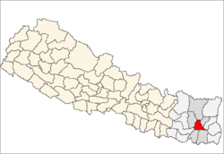
 Location of Dhankuta |
|
| Country | |
| Region | Eastern (Purwanchal) |
| Zone | Kosi |
| Headquarters | Dhankuta |
| Area | |
| • Total | 892 km2 (344 sq mi) |
| Population (2011[1]) | |
| • Total | 163,412 |
| • Density | 180/km2 (470/sq mi) |
| Time zone | NPT (UTC+5:45) |
| Main language(s) | Newari, Rai, Tamang, Magar, Limbu etc. |
| Website | www.ddcdhankuta.gov.np |

Playground in Basantatar VDC, Dhankuta
Contents
Geography and Climate
| Climate Zone[2] | Elevation Range | % of Area |
|---|---|---|
| Lower Tropical | below 300 meters (1,000 ft) | 3.7% |
| Upper Tropical | 300 to 1,000 meters 1,000 to 3,300 ft. |
44.7% |
| Subtropical | 1,000 to 2,000 meters 3,300 to 6,600 ft. |
46.6% |
| Temperate | 2,000 to 3,000 meters 6,400 to 9,800 ft. |
3.2% |
Municipality and Village Development Committees (VDCs)
Municipality
Village Development Committees (VDCs)
- Ahale
- Ahale
- Ankhisalla
- Arkhaule Jitpur
- Basantatar
- Belhara
- Budhabare
- Bhirgaun
- Bodhe
- Budhabare
- Budi Morang
- Chanuwa
- Chhintang
- Chungmang
- Danda Bazar
- Dandagaun
- Faksib
- Falate
- Ghortikharka
- Hattikharka
- Jitpur Arkhaule
- Khoku
- Khuwafok
- Kuruletenupa
- Leguwa
- Mahabharat
- Marek Katahare
- Maunabudhuk
- Mudebas
- Muga
- Murtidhunga
- Pakhribas
- Parewadin
- Raja Rani
- Sanne
- Tankhuwa
- Telia
- Vedetar
See also
References
- ^ Household and population by districts, Central Bureau of Statistics (CBS) Nepal
- ^ The Map of Potential Vegetation of Nepal - a forestry/agroecological/biodiversity classification system, . Forest & Landscape Development and Environment Series 2-2005 and CFC-TIS Document Series No.110., 2005, ISBN 87-7803-210-9, retrieved Nov 22, 2013
- Districts of Nepal at statoids.com
| This Nepalese location article is a stub. You can help Wikipedia by expanding it. |


